The 1995 film “The Usual Suspects” was filmed mostly in Southern California, with a few scenes shot in New York City.
Keaton, played by Gabriel Byrne, needs to catch a flight from New York to California. At the Flatiron Building in Manhattan, he wants to tell his attorney girlfriend goodbye, but Verbal Kint, played by Kevin Spacey, pushes him to leave without doing so, as they are running late. The building has appeared in countless films, such as “Spider-Man,” “As Good As It Gets,” “I Am Legend” and many more.
LOCATION: 175 5th Ave, New York, NY 10010
The suspects meet up with Redfoot at the Korean Bell of Friendship in San Pedro, California. Perched right in front of a spectacular ocean view, it’s a great place to visit, even if you’re not a fan of the film. The bell was given as a gift by South Korea to celebrate the U.S. bicentennial in 1978. It has also appeared in the films “It’s Pat: The Movie,” “Brink!” and the 2023 remake of “White Men Can’t Jump,” as well such TV shows as “Alias,” “Wonder Woman” and “Street Hawk.”
LOCATION: 3601 Gaffey St, San Pedro, CA 90731
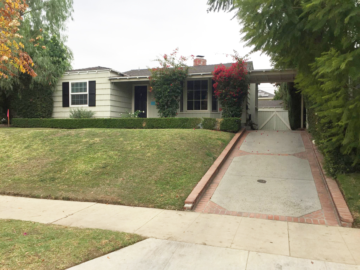
The flashback scenes of Keyser Söze’s Turkish home, where his family is attacked, were actually filmed at the McNally House in Altadena. The home has been featured in such films as “Elizabethtown,” “Beautiful Boy” and “Kingdom Come,” as well as such TV shows as “Entourage,” “Hacks,” “Ghost Whisperer” and more. The house is only seen from interior views in the film. The home was destroyed by wildfires in 2025.
LOCATION: 654 E Mariposa St, Altadena, CA 91001
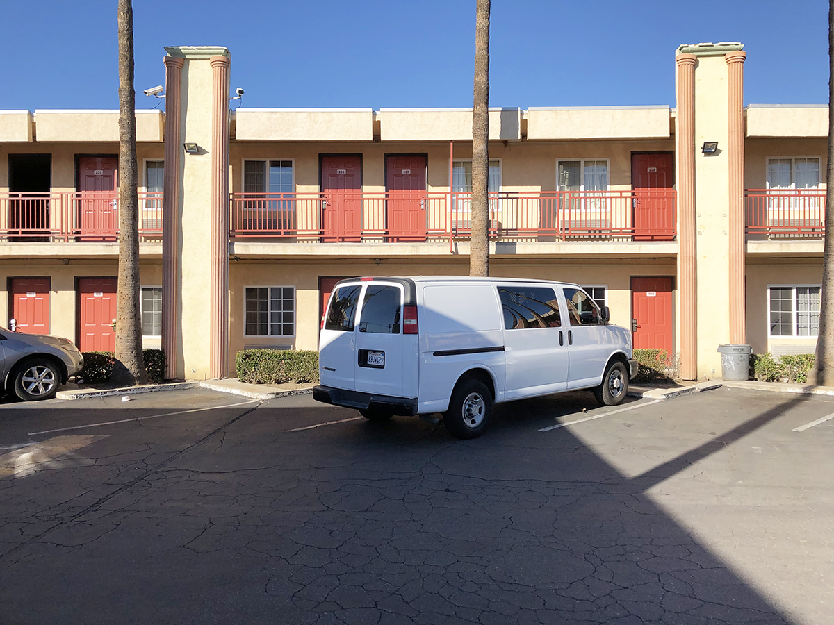
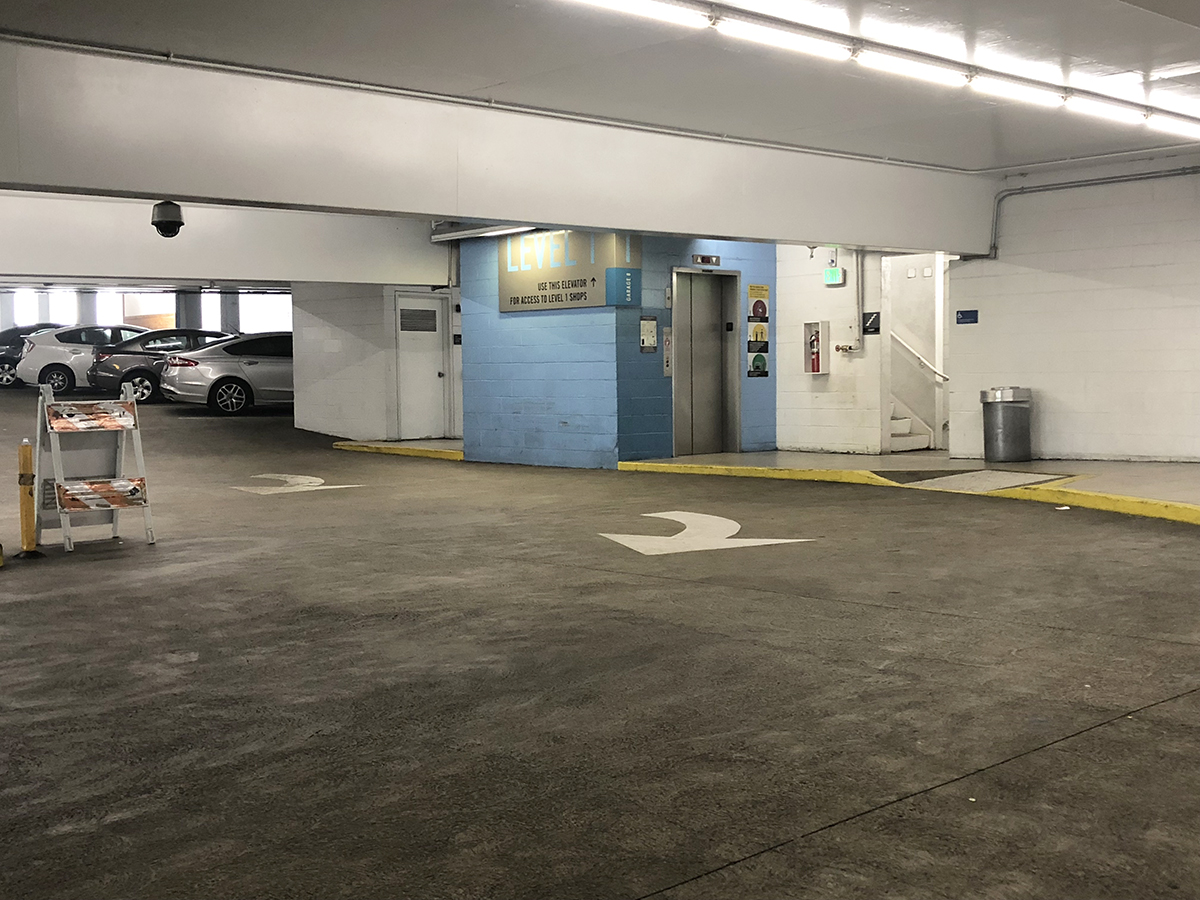
The police station seen in the film is the San Pedro Municipal Building. The same building appeared in the film “C.H.U.D. II: Bud the Chud.”
LOCATION: 638 S Beacon St, San Pedro, CA 90731
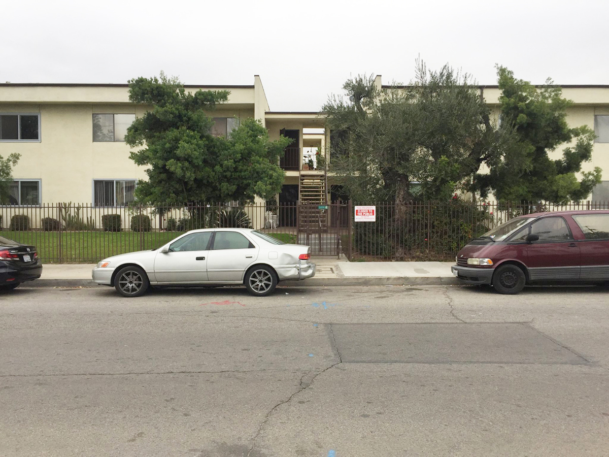
Near the end of the film, after he posts bail, Verbal Kint walks down this sidewalk out front.
Dave Kujan, played by Chazz Palminteri, just misses a vehicle as it turns down W 6th St in San Pedro.
While set in the town of Ossining, New York, Don Draper’s house from the TV series “Mad Men” is located in Pasadena, California. It’s actually right around the corner from the house from the movie Father Of The Bride.
David Lynch’s “Lost Highway” shot around Southern California, Death Valley and the Nevada desert. Early in the film, Fred and Renee, played by Bill Pullman and Patricia Arquette respectively, receive a mysterious video tape at their doorstep. David Lynch used his own home as the location.
LOCATION: 7035 Senalda Rd, Los Angeles, CA 90068
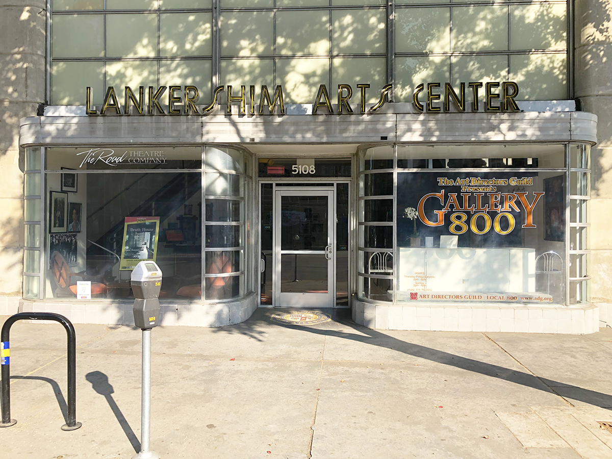
Fred plays his saxophone at the Luna Lounge. This was filmed at the Lankershim Arts Center in North Hollywood.
LOCATION: 5108 Lankershim Blvd, North Hollywood, CA 91601
Fred ends up on death row for the murder of his wife. The cell block wasn’t a prison at all, rather a creative re-purposing of a decommissioned fire station in downtown Los Angeles. The same station was used for interior scenes for the original “Ghostbusters” firehouse, as well as “The Mask,” “Flatliners,” “Set It Off,” “Big Trouble In Little China” and more. Only the interiors were used in the film, but here is a view of the exterior. Today, the surrounding area has become run down and it isn’t the safest of places.
LOCATION: 225 E 5th St, Los Angeles, CA 90013
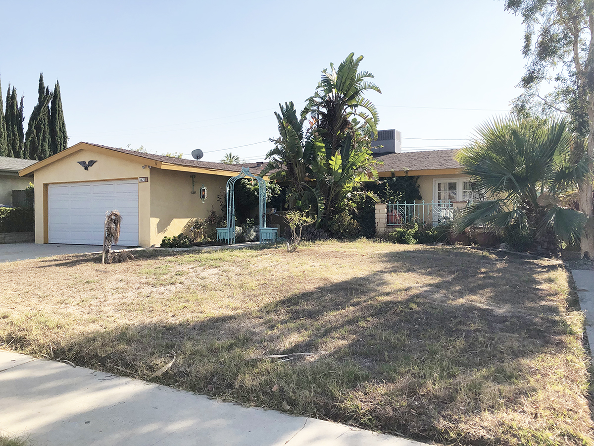
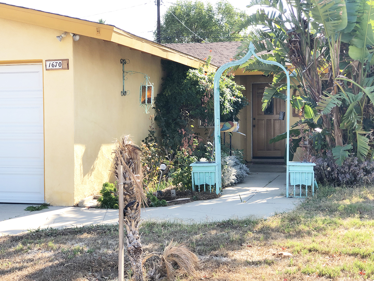
After some mysterious events, Pete, played by Balthazar Getty, awakens in Fred’s jail cell. Baffled by this phenomenon, the police decide to release him. Pete returns to his home, located in Northridge.
LOCATION: 16706 Citronia St, Northridge, CA 91343
Pete’s girlfriend Sheila, played by Natasha Gregson Wagner, lives at this house, located just a few blocks away from Pete’s place.
LOCATION: 9532 McLennan Ave, Northridge, CA 91343
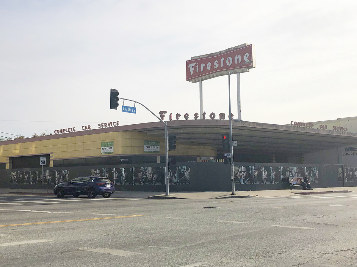
Pete works as a mechanic at Arnie’s, which was filmed at the Firestone building in Los Angeles. No longer in service, the building, built in 1937, is designated as an historical monument by the city.
LOCATION: 800 South La Brea Ave, Los Angeles, CA 90036
The place where Mr. Eddy becomes enraged at a tailgating driver requires a bit of effort if you want to visit the location. It was filmed on Mt Hollywood Dr, near the Griffith Observatory. Contrary to what is seen in the film, the road is actually completely inaccessible to the public by vehicle. It is found along a fully paved road, but the road is gated off in all directions from motor vehicles. Aside from park rangers, the road is primarily used by hikers and bicyclists.
The easiest way to visit is by parking at the Griffith Observatory. The lot at the Observatory itself is almost always full. You’re unlikely to find a spot in the actual lot. However, you can park along East or West Observatory Road. Unfortunately, these are now paid parking spaces and somewhat expensive. There are a few free auxiliary lots, but those fill up quickly as well, plus they put you pretty far away from where you need to be to get to the location. You shouldn’t have a difficult time finding a paid parking space on Observatory Road, unless you’re arriving at peak evening hours. Your best bet is to arrive early.
The easiest way to spot the trail head to reach the location is to look for the tunnel when approaching Griffith Observatory. Most traffic to reach the Observatory passes through it. The tunnel was famously seen in Back To The Future Part 2, when Biff and Marty McFly (riding a hoverboard) fight over a sports almanac. The very first road on your right, once you pass through the tunnel, is where you will need to hike. It will either be gated off, or if the gates are open, a guard will be parked there, making sure no motorists attempt to drive up it. The road is freely accessible to pedestrians on foot or bike, however, and you’ll likely see a lot of both. You simply take that road for about 0.5 miles to reach the location. At least you can take photographs in relative safely here, without concern for traffic on the road.
LOCATION: Mt Hollywood Dr, Los Angeles, CA 90027 (GPS coordinates: 34.126026, -118.306921)
It is a moderate hike. Much of it is uphill, but considering you can walk a paved road the entire way, as well as the fact that there are resting spots, it’s certainly manageable for most. A bottle of water should suffice, unless it’s an extremely hot day.
If you want to get the most out of your money for paying for a parking space near Griffith Observatory, we recommend continuing along the same path to the location of the dance scene in “La La Land.” That location is another 1.5 miles up the same road.
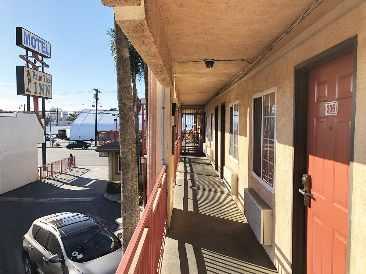
After Alice meets Pete at the mechanic’s, the pair begin an affair. Alice is waiting at the Palm Tree Inn in North Hills, calling down to him from the second floor to say that she already got them a room.
LOCATION: 8424 Sepulveda Blvd, North Hills, CA 91343
Pete pulls up to this spot in the parking lot, where he talks to Alice.
The cops watch from the parking lot as the two go into the hotel room. The same motel has also been seen in the TV series “My Name Is Earl.”
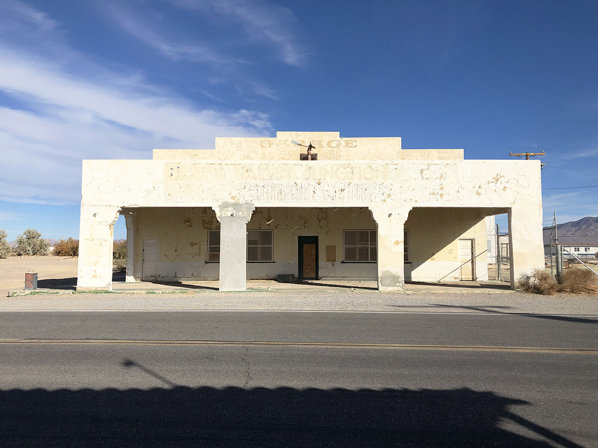
Near the end of the film, Fred arrives at the Lost Highway Hotel. This was actually a composite of two separate buildings. The exterior, seen below, is an abandoned building located at Death Valley Junction, near the California / Nevada border. The same building was seen in the 1986 film “The Hitcher.” The interior corridors were actually filmed across the street at the Amargosa Opera House and Hotel (608 Death Valley Jct, Death Valley, CA 92328). This area is very much in the middle of nowhere.
LOCATION: Near the intersection of State Line Rd / CA-127, Death Valley Junction, CA 92328 (nearest address is 608 CA-127, Death Valley Junction, CA 92328)
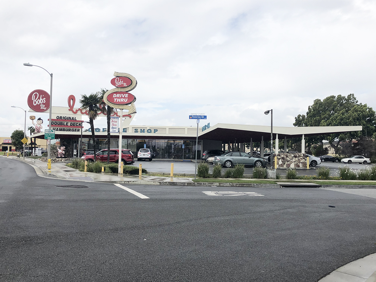
A deleted scene with Pete and Sheila was was filmed at the former Johnie’s Broiler in Downey. Some footage can be seen in the film “Pretty as a Picture: The Art of David Lynch.” The restaurant has a unique history, having appeared in many other films, such as “Heat,” “Short Cuts,” “License To Drive,” “The Game,” “My Stepmother Is An Alien,” “What’s Love Got To Do With It,” “One Hour Photo” and many more. In 2007, the building was demolished. However, Bob’s Big Boy purchased the property years later and rebuilt it based on the original blueprints and even some of the same materials. So what stands now closely resembles what was there before.
LOCATION: 7447 Firestone Blvd, Downey, CA 90241
To see our “Lost Highway” location page, click here.
The 1980s classic “The Karate Kid” shot mostly around the San Fernando Valley in California. Surprisingly, many of the film locations are not only still standing, but still closely resemble how they appear in the film. The major exception is Mr. Miyagi’s house, which was torn down.
Daniel Larusso’s apartment still exists in Reseda, California. The apartment looks identical to how it appeared in 1984. However, the neighborhood it’s located in isn’t the safest of areas.
LOCATION: 19223 Saticoy St, Reseda, CA 91335
Daniel embarrassingly arrives in his mom’s run-down car to pick up Ali at her house for a date. This house has since been remodeled.
LOCATION: 4072 Alonzo Ave, Encino, CA 91316
The two go on a date to Golf N’ Stuff, which is a real place and still open to visitors. It’s located further south, down in Norwalk, California.
LOCATION: 10555 Firestone Blvd, Norwalk, CA 90650
The location of the Cobra Kai dojo can be found in North Hollywood. The same location was featured in the film “Say Anything…“
LOCATION: 5223 Lankershim Blvd, Los Angeles, CA 91601
One of the most critically acclaimed films of the 1990s, Quentin Tarantino’s “Pulp Fiction,” was shot in Southern California. The restaurant that opens and closes the film was the Hawthorne Grill in Hawthorne, California. Unfortunately, the restaurant closed in 1996 and is now an AutoZone.
LOCATION: 13763 Hawthorne Blvd, Hawthorne, CA 90250 (demolished)
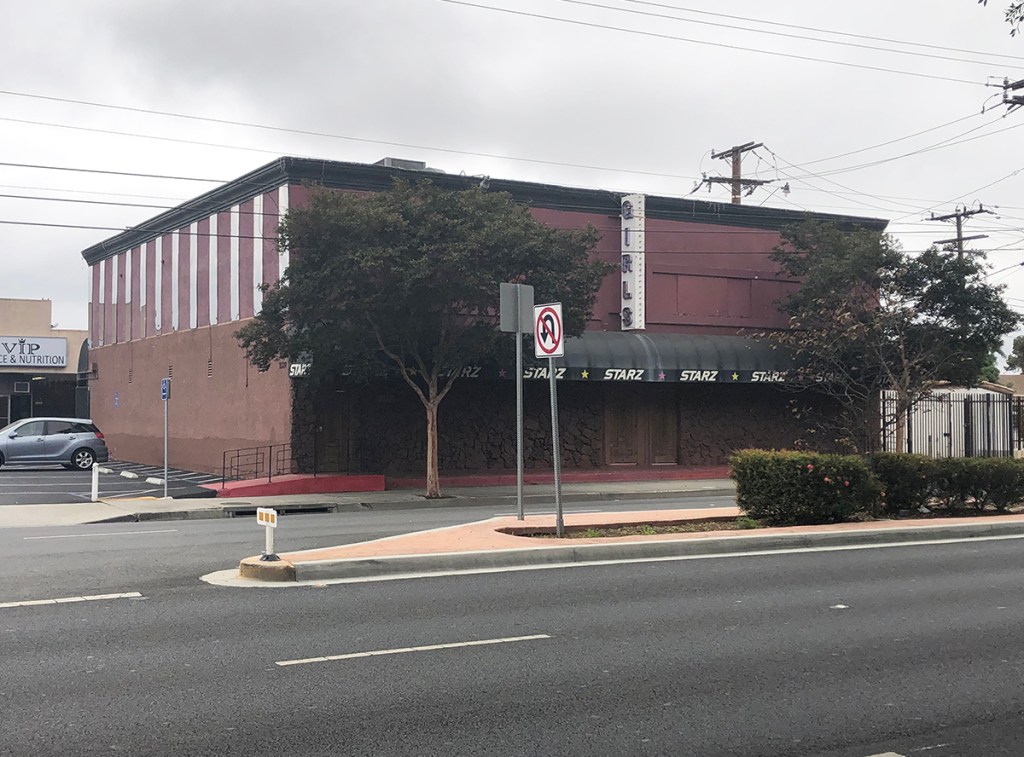
Butch discusses throwing a boxing fight with Marsellus Wallace at Starz, a former strip club in Gardena. This location was identified by Rayen Belchere after he spoke with the former management, who confirmed the club was used in the film. The location is only seen from interior views in the film, but photography was not permitted inside and the club has since permanently closed. Here is what the exterior looked like.
LOCATION: 2528 Rosecrans Ave, Gardena, CA 90249
Vincent Vega takes Mia Wallace to the memorable “Jack Rabbit Slims,” which is not a real restaurant. The interiors were built on a studio stage. However, the exterior is in fact a real place, albeit not a restaurant. Located in Glendale, California, the building was originally a bowling alley called Grand Central Bowl, which has long since closed. Today, the building is owned by The Walt Disney Company, which owned Miramax, the company which released “Pulp Fiction.” The building is part of Disney’s larger Grand Central Business Center, which consists of numerous buildings in the area used as business offices. The building is actually tucked away behind a wall and fencing, but the wall is not very tall and it’s easy to get a view over top of it. What is not so easily accomplished is getting a closer view of the building. The property is only open to business staff, so the closest the public can get is the sidewalk.
LOCATION: 1435 Flower St, Glendale, CA 91201
Vincent Vega pays a visit to his friend Lance, played by Eric Stoltz, early in the film, in order to purchase some heroin. After Mia Wallace mistakes Vega’s heroin for cocaine, she overdoses and is rushed to this house in the Atwater Village neighborhood of Los Angeles, for a very tense scene in which they give her an adrenaline shot.
LOCATION: 3519 La Clede Ave, Los Angeles, CA 90039
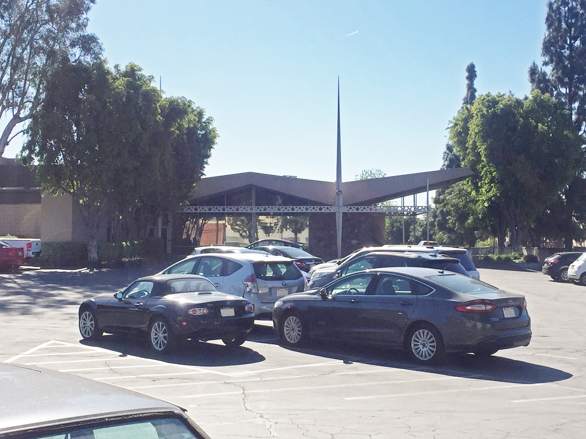
The building where Butch’s boxing match takes place can be found in Pasadena. The marquee has since been changed. The same building was also used in “This is Spinal Tap.”
LOCATION: 129 N Raymond Ave, Pasadena, CA 91103
Later in the film, after Butch has double-crossed Marsellus Wallace, he sneaks back to his apartment, located in North Hollywood, to retrieve his gold watch. A different apartment, located at 11755 Gilmore St, North Hollywood, CA 91606, was used for the courtyard and interiors. Today, that building is no longer accessible to the public.
LOCATION: 11813 Runnymede St, North Hollywood, CA 91605
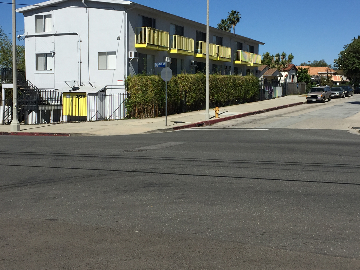
After a violent confrontation at his apartment, Butch is leisurely driving away, when a chance encounter with Marsellus occurs at this intersection of Fletcher Dr. and Atwater Ave., also located in Atwater Village. Butch is facing NW on Atwater Ave. when he spots Marsellus crossing Fletcher Dr.
LOCATION: Intersection of Atwater Ave. / Fletcher Dr., Los Angeles, CA 90039
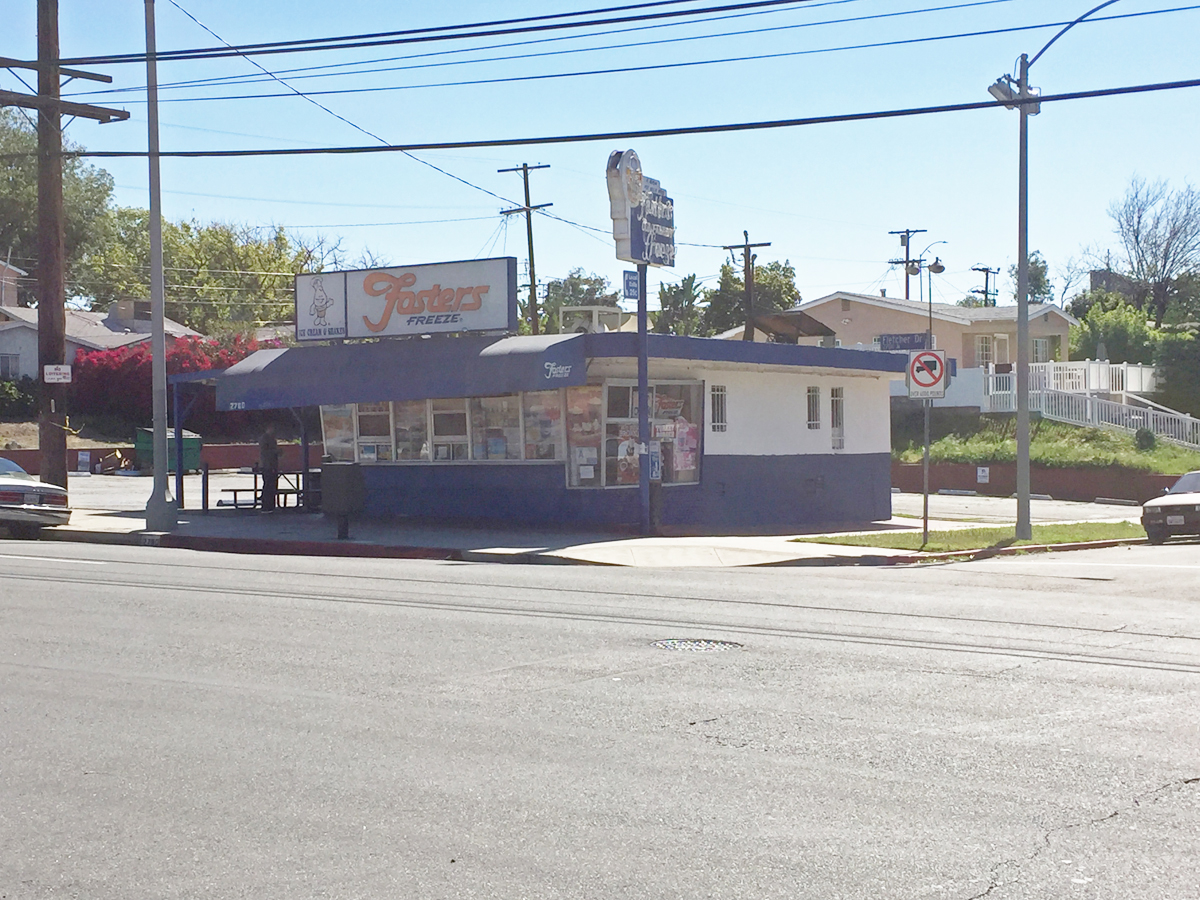
Butch quickly floors it and hits Marsellus, before getting in a car collision in the intersection. Marsellus awakens and begins firing his gun at Butch, when a bystander is hit in front of Fosters Freeze, which is at the same intersection. Forsters Freeze was also featured on the television show “GLOW.”
LOCATION: 2760 Fletcher Dr, Los Angeles, CA 90039
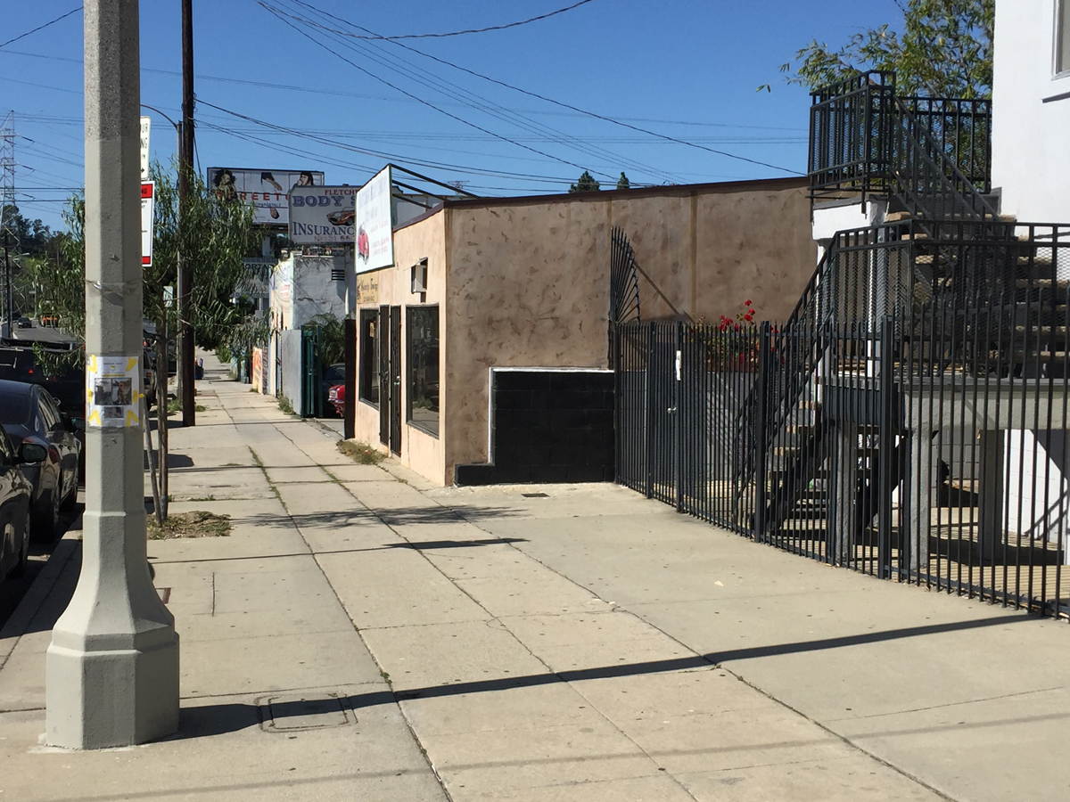
Marsellus chases Butch on foot SW down Fletcher Dr. from the same intersection.
LOCATION: Fletcher Dr., just past Atwater Ave., Los Angeles, CA 90039
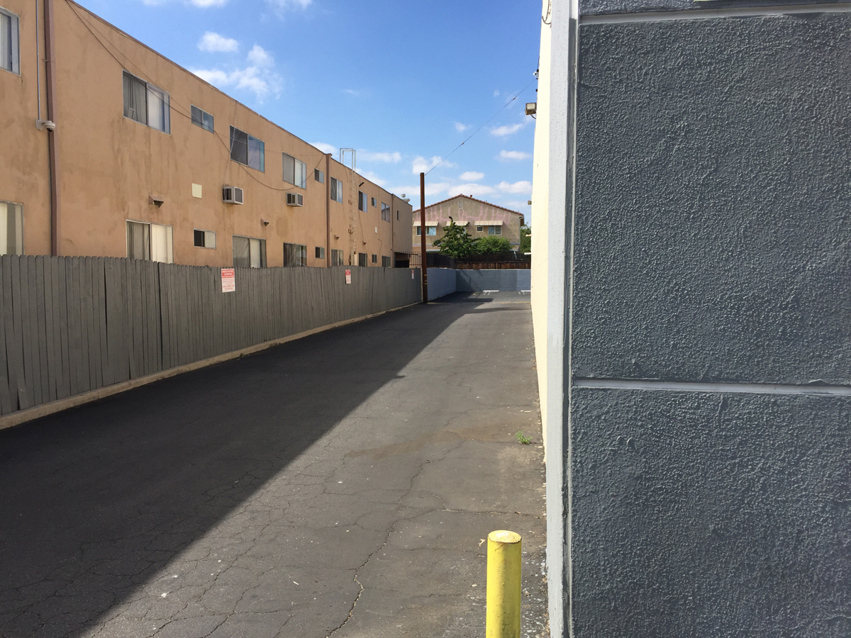
Marsellus fires one last shot in the distance at Butch, who is standing at the corner of this building in Canoga Park. This location is far away from the earlier shots in Atwater Villiage. It is actually the corner alley next to the Zed’s Pawn Shop, in which both characters make a grave mistake in entering.
LOCATION: The alley left of Crown Pawn Shop at 20933 Roscoe Blvd, Canoga Park, CA 91304
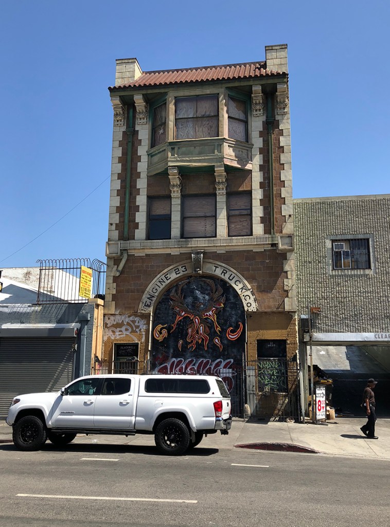
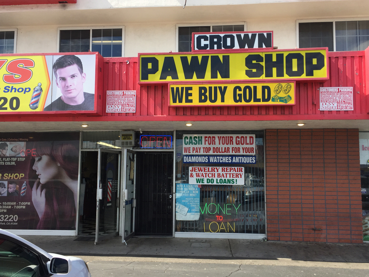
Zed’s Pawn Shop is where things take a bizarre, ugly turn for Butch and Marsellus. The real building actually is a pawn shop.
LOCATION: 20933 Roscoe Blvd, Canoga Park, CA 91304
The motel where Butch and Fabienne stay was demolished in 1996. Formerly known as the River Glen Motel, this building now stands in it’s place. Only the exteriors were used in the film. The interior of the motel was a set, albeit designed to resemble the River Glen Motel rooms.
LOCATION: 2934 Riverside Dr, Los Angeles, CA 90039 (now demolished)
What can be better lined up at the location is the view down Riverside Drive, seen as the couple leaves the motel on a chopper. Everything here still matches how it appeared in the film, with the Glendale-Hyperion Bridge visible in the distance. The same bridge was seen in the film “Who Framed Roger Rabbit?”
Near the end of the film, Jules and Vincent find themselves in “The Bonnie Indecent,” in which they are in sudden, urgent need of getting rid of a body. They arrive here at Jimmy’s house, played by Quentin Tarantino. It is here they meet “The Wolf,” played by Harvey Keitel.
LOCATION: 4145 Kraft Ave, Studio City, CA 91604
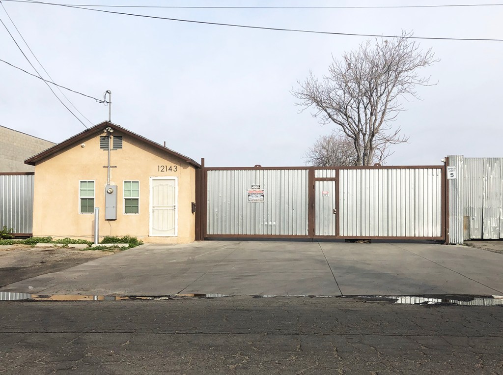
The site of Monster Joe’s Truck and Tow can be found in Sun Valley. The area has changed some since filming took place.
LOCATION: 12143 Branford St, Sun Valley, CA 91352
To see our “Pulp Fiction” location page, click here.
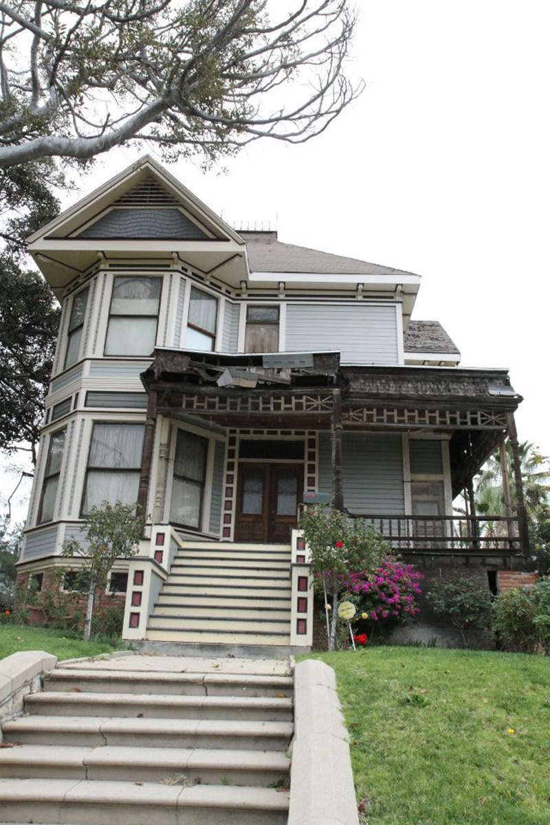
The house from “Father of the Bride” can be find in a quiet neighborhood in Pasadena, California. The house still looks nearly identical to how it appeared in the film.
Right around the corner in this same neighborhood is the house from Mad Men.
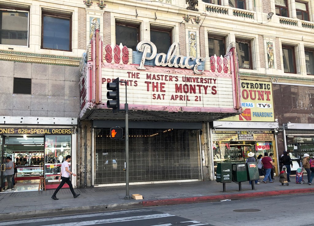
Michael Jackson’s classic music video for “Thriller” was filmed around Los Angeles, California. The exterior of the theater where Michael watches watches a film can be found in Downtown Los Angeles.
LOCATION: 630 S Broadway, Los Angeles, CA 90014
In the Angelino Heights neighborhood near Echo Park, you’ll find the house from the video. The same home appeared in the film “Teen Witch.” Just a couple doors down is the house from “Charmed” (also seen in “Deuce Bigalow: Male Gigolo”) and across the street is the house from “Grandma’s Boy.”
LOCATION: 1345 Carroll Ave, Los Angeles, CA 90026
The dance scenes in the street were filmed in Downtown Los Angeles. This area has since become heavily populated by the homeless.
LOCATION: Union Pacific Ave / Calzona St, Los Angeles, CA 90023
James Cameron’s iconic sci-fi action sequel, “Terminator 2: Judgment Day,” shot all around California, primarily in the Los Angeles, San Fernando Valley and Fremont areas. Here we’ll take a look at some of these spots.
The T-1000 travels back in time and arrives underneath the 6th St bridge in Downtown Los Angeles, where he kills a police officer and takes his car, beginning his search for John Conner. The 6th St Bridge has been used in countless films. The original bridge was demolished in 2016, with a new bridge built in its place in 2022. The area where the scene took place has changed quite a bit.
LOCATION: Under the 6th St. Bridge, at the intersection of lower E 6th St / Santa Fe Ave, Los Angeles, CA 90013 (heavily remodeled)
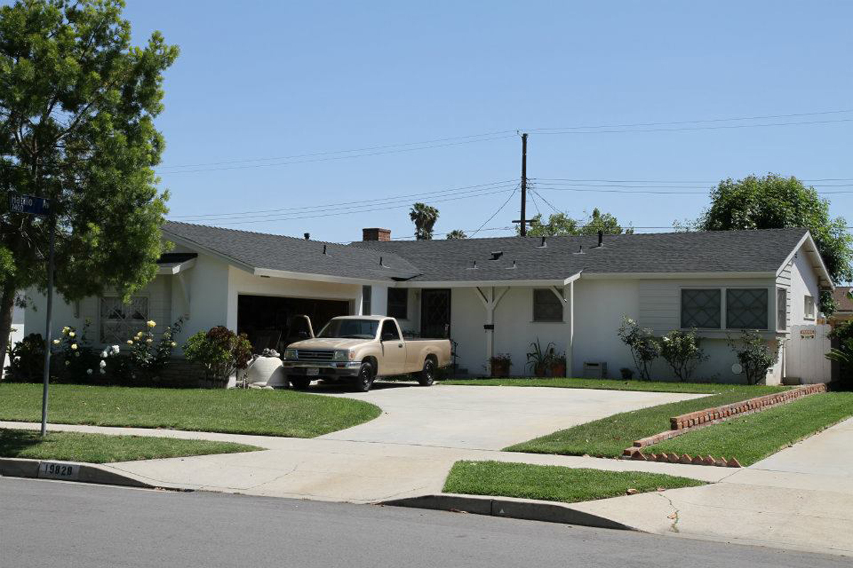
John Conner lives at this house in Canoga Park with his foster parents. The T-1000 later arrives searching for John.
LOCATION: 19828 Valerio St, Canoga Park, CA 91306
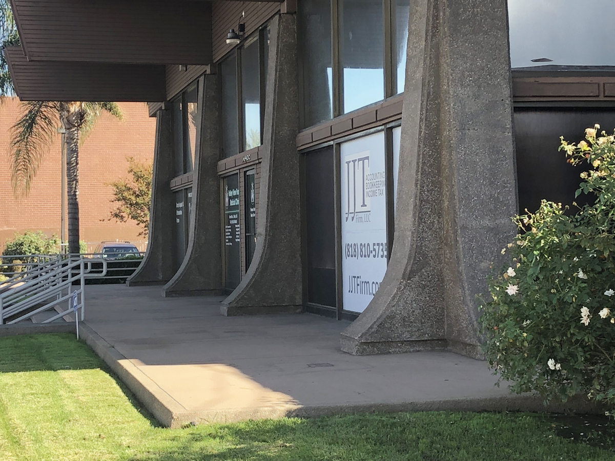
John Conner and a friend rob an ATM at this former bank in Van Nuys, California. The building is now a pharmacy and is fenced off from the street, with no trespassing signs. It’s still fairly easy to photograph from the sidewalk, however.
LOCATION: 14400 Roscoe Blvd, Van Nuys, CA 91402
After the T-1000 spots John Conner, he begins to pursue him, as John flees down the stairwell of a parking garage. This is a garage at the Santa Monica Place shopping center. Despite appearances, it’s actually not too difficult to match up the areas used in the film.
LOCATION: 395 Santa Monica Place, Santa Monica, CA 90401
John races over to his bike.
The T-1000 chases him at an inhuman speed.
A look at some other shots seen during the bike chase…
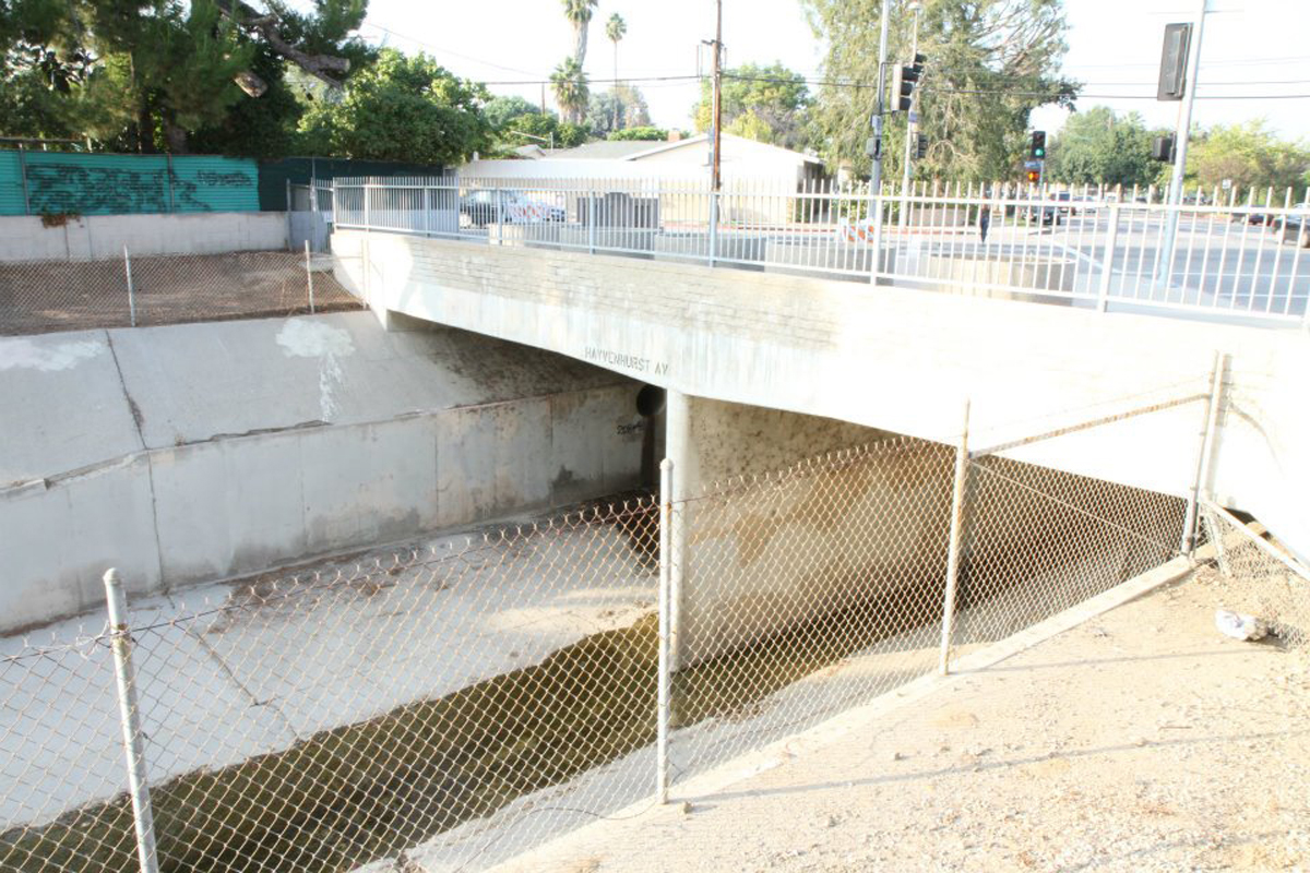
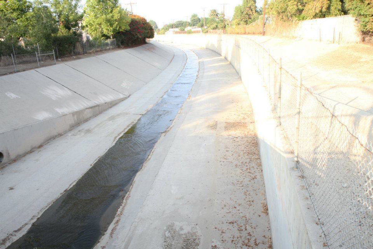
In one of the most famous scenes in the film, after thinking he’s finally escaped the T-1000, due to some help from the T-800, John is surprised when the T-1000 drives a semi truck through the overpass wall of Bull Creek, a flood control channel located in North Hills.
LOCATION: Bull Creek, SW corner of Plummer St, near Hayvenhurst Ave, North Hills, CA, 91343
Here is a view of the Bull Creek channel, where John Conner is chased on his dirt bike by the T-1000.
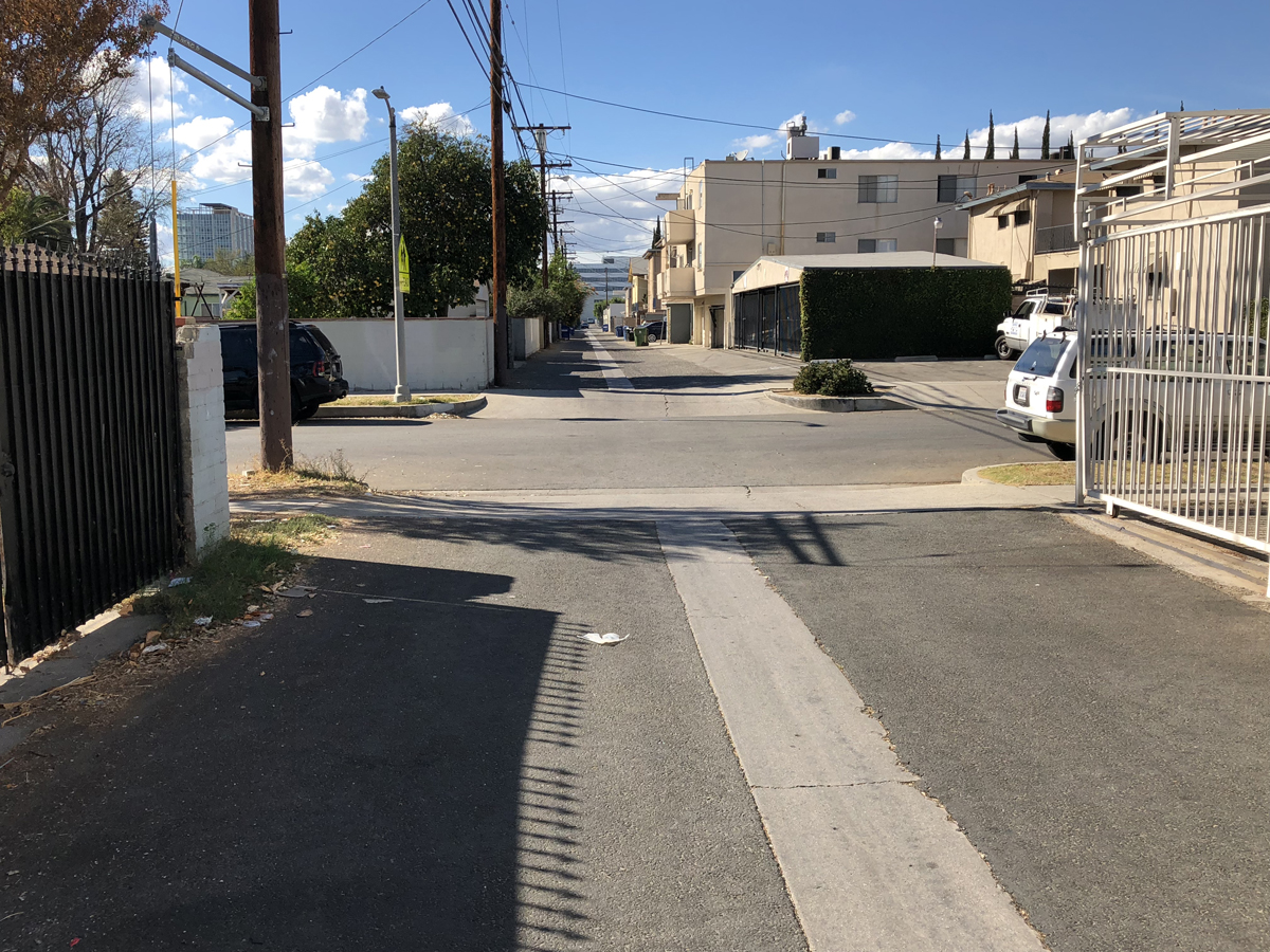
After The Terminator saves John Conner, Conner asks him to stop the bike at this alley in Van Nuys, where he questions him on his mission. The alley is located very close to the bank where John Conner robs the ATM.
LOCATION: Alley on Wakefield Ave, between Burton St and Roscoe Blvd, Van Nuys, CA 91402
Sarah Conner, played by Linda Hamilton, is being held at the Pescadero State Hospital for the Criminally Insane. These scenes were shot at the Phoenix House for Drug and Alcohol Rehabilitation. We did not replicate the exact angles seen of the building in the film, as those sections are now entirely obscured by a row of trees.
LOCATION: 11600 Eldridge Ave, Lake View Terrace, CA 91342
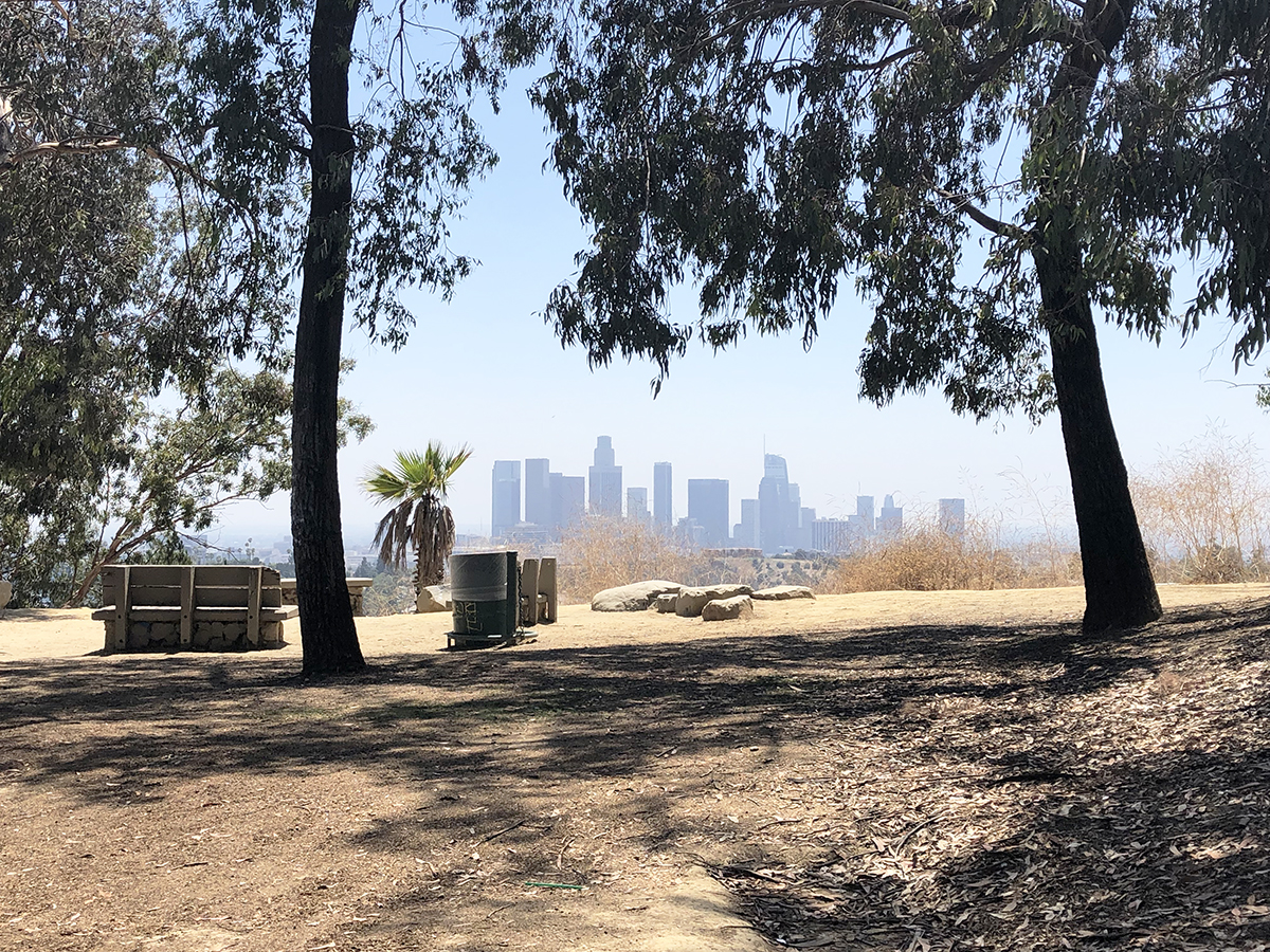
Sarah has a dream in which she approaches a playground as Judgment Day begins. This was filmed at Elysian Park, overlooking Dodger Stadium and Downtown Los Angeles. The park has changed quite a bit and the chain link fence is long gone, but the city skyline can still be matched up. This area is near Elysian Fields on Park Road, where it ends in a cul-de-sac. The playground has been moved up closer to the road and the area seen in the film is now a lookout point.
LOCATION: Near Elysian Fields, Park Rd, Los Angeles, CA 90012 (GPS coordinates: 34°04’56.8″N, 118°14’23.4″W)
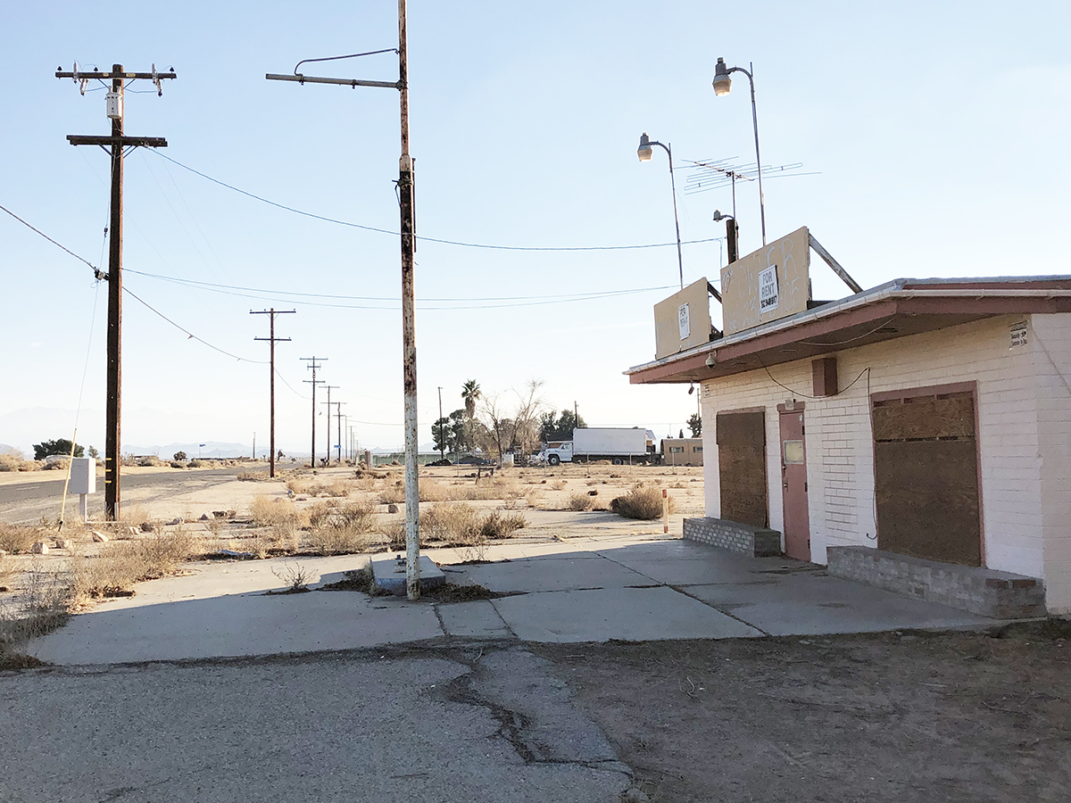
The T-800, Sarah and John stop off at this desert market and gas station, as they make their way to the Salceda ranch. Although long since closed, the property is still recognizable from the film. However, a fence has since been erected around it, blocking some of the views. The same building was featured in the film “From Dusk Till Dawn.”
LOCATION: 46551 140th St E, Lancaster, CA 93535
The house of Miles Dyson, played by Joe Morton, can be found in Malibu. The home sits up a long, gated driveway, so the only views are looking up from Pacific Coast Highway. The same home appeared in the film “Win a Date with Tad Hamilton!”
LOCATION: 30068 E Pacific Coast Hwy, Malibu, CA 90265
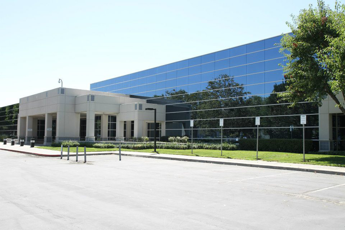
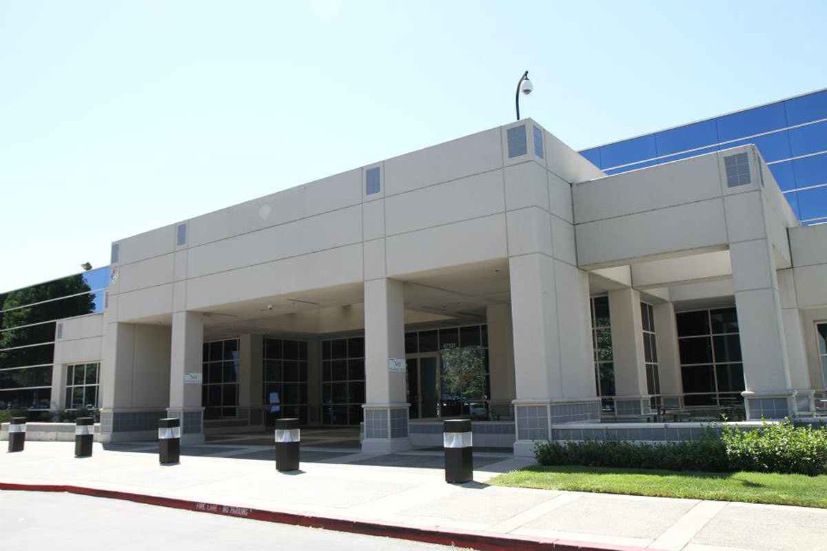
Later in the film, the Terminator, John and Sarah Conner all break into the Cyberdine Headquarters, where Skynet will be created, launching Judgment Day. The real building is located in Northern California in the city of Fremont. Ironically, the building actually belongs to a real tech company, Mattson Technology.
LOCATION: 47131 Bayside Pkwy, Fremont, CA 94538
A closer look at the entrance, where the SWAT truck crashes through.
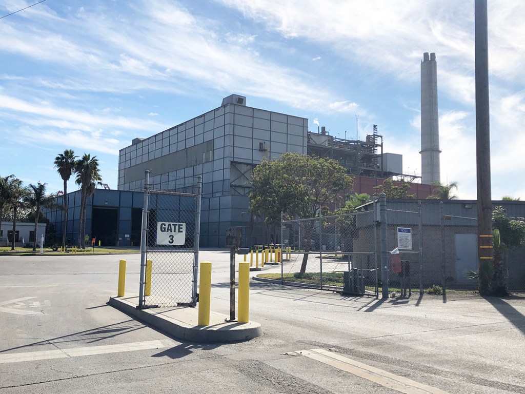
The exterior of the factory where the ending takes place can be found in Long Beach. The same building appeared in the film “Child’s Play 2.”
LOCATION: 118 Pier S Ave, Long Beach, CA 90802
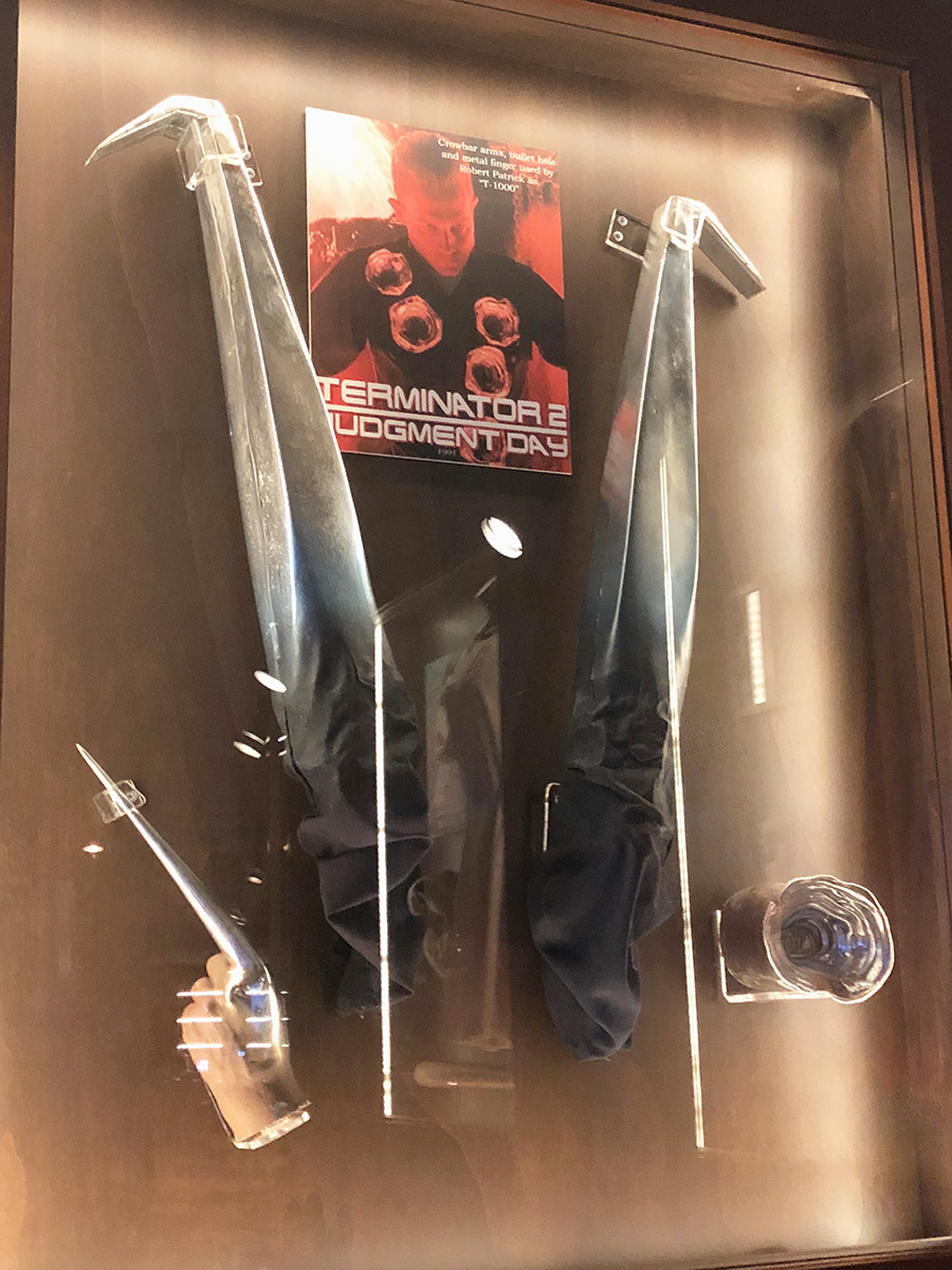
We leave you with some props from the film. The T-1000’s crowbar arms, stabbing finger and liquid metal bullet wound can be found on display at Planet Hollywood in Florida.
LOCATION: 1506 E Buena Vista Dr, Lake Buena Vista, FL 32830
One of the most remote locations you’ll ever likely encounter is Barker Ranch in Death Valley, California. It was the last hideout of Charles Manson and the Manson Family. Getting there is no easy task and requires planning and caution, due to the extreme desert conditions. To begin, you’ll have to head to the virtual ghost town of Ballarat, California, located in Inyo County. There are a few scattered people who pass through Ballarat, who are usually deliberately attempting to stay on the outskirts of society. One of the few buildings you’ll see in the town is the Ballarat Trading Post.
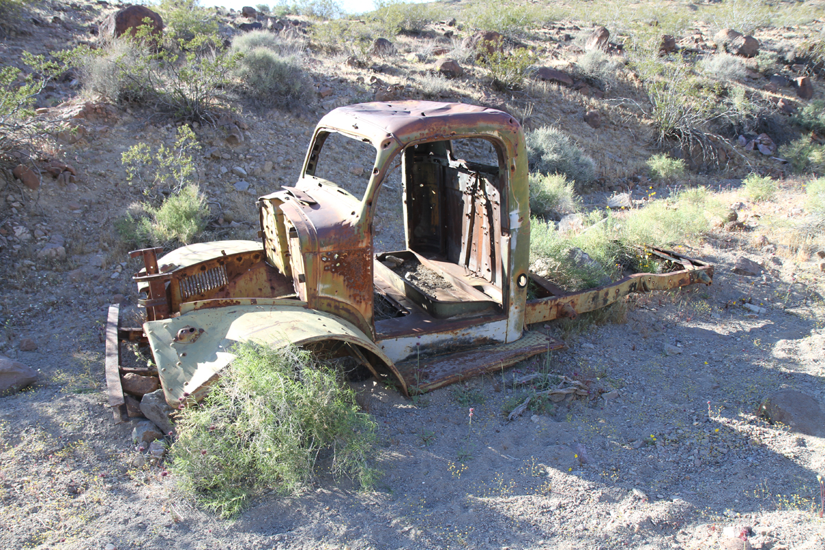
Directly in front of the Ballarat Trading Post is this truck, which for years has been rumored to have belonged to Manson Family member Charles “Tex” Watson. The rumor even got distorted one degree further, with some eventually claiming Charles Manson himself once owned it. The most common story is that when “Tex” fled Barker Ranch for Texas, he took this truck, which quickly broke down in Ballarat (Watson hitchhiked from there). However, according to locals, the actual truck “Tex” drove ultimately fell into the hands of another Ballarat local after it broke down, who was the caretaker of a nearby mining camp. He is said to have eventually dismantled the Watson escape truck. The one that sits in front of the trading post is similar, but locals claim it was never a Manson Family truck. However, the truck has sat in the same spot for quite some time and was likely in Ballarat at the time the Family was there, even if there is no direct connection. There is another truck, which is much more strongly argued to have belonged to “Tex” Watson, located at Barker Ranch itself.
Another old, rusty truck body, located near the Ballarat Trading Post.
To get to Barker Ranch, you will need to take a right at the Ballarat Trading Post, down Coyote Canyon Road. Surprisingly, most GPS systems, including Google Maps, can navigate you to Barker Ranch. However, it is strongly advised not to rely solely on GPS. Some GPS systems can be a bit off and cellular service is nowhere to be found in this region. So it is highly advisable to bring written or printed directions as well. There are no paved roads here, everything is dirt roads. Without a 4-wheel drive vehicle, Coyote Canyon Road is about as far as you will likely make it in a standard vehicle. Once you reach Goler Wash Road, you will likely traverse no further, unless its on foot or in a 4×4 vehicle. Here is a photo of the entrance of Goler Wash, which does not do justice to how rough the road truly gets.
Goler Wash is occasionally graded by the National Parks Service, which makes driving the road much easier. You can check online to see the various road conditions in a given season around Death Valley. Even with the road graded, its still difficult in certain spots. Even though it isn’t a long road, it will take you quite a long time to drive through it, due to the canyons becoming quite narrow at times (you can probably touch the rocky walls from your vehicle at various points). There is also a regular stream of water that runs through the wash. Depending on the season, this can be minor or significant. At one point along Goler Wash, you even need to drive up a small waterfall. Depending on the amount of water runoff, this can be fairly difficult. Another factor is simply all the loose rocks and gravel beneath you as you drive. It is recommended that an experienced off-road driver handle this road, but if conditions are agreeable in certain seasons, its possible for a first time off-road driver to handle it. Do your research and be careful if you do elect to attempt it.
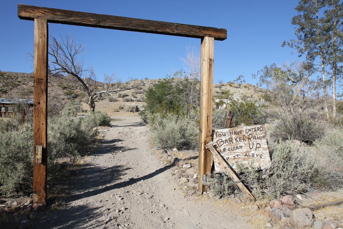
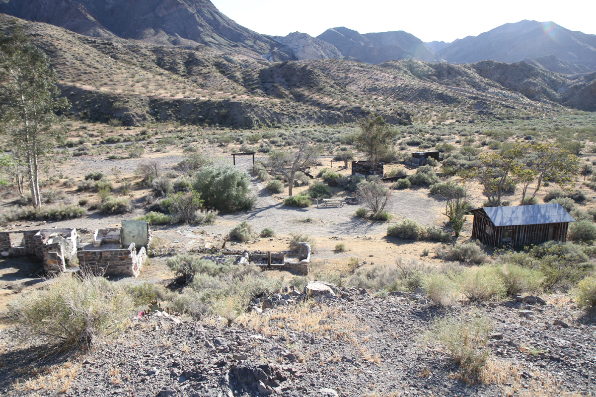
Once you get through the war of attrition that is driving Goler Wash, you will finally arrive at Barker Ranch and Myers Ranch. Charles Manson first became aware of the ranches through Manson Family member Kathy Gilles, whose grandparents lived there. She brought Manson to the property, which he immediately liked for both its seclusion from society, as well as its perceived freedom from authority. Eventually, the Family began occupying both ranches, after Manson offered a Beach Boys gold record in exchange for permission to remain on the properties. While the Tate / LaBianca murders were planned from Spahn Ranch, it is Barker Ranch where Charles Manson and most members of the Manson Family were finally captured.
The path up to Myers Ranch and Barker Ranch.
The gates of Barker Ranch.
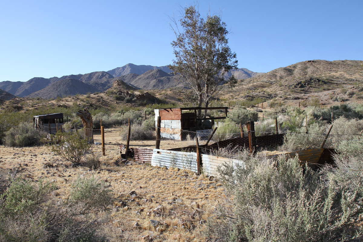
Some remnants of the outbuildings and stables at the ranch.
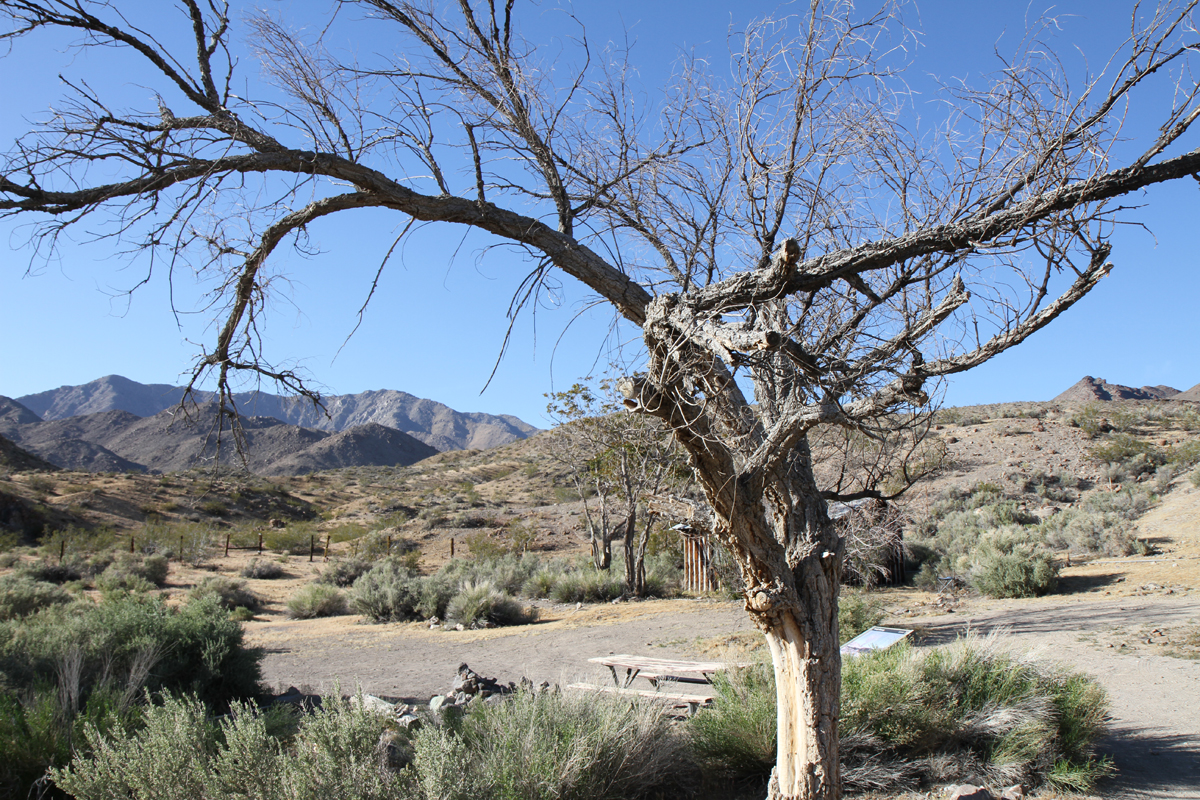
A plaque at the ranch, made by the National Parks Services, noting the history of the ranch. It shows a photo of what the ranch looked like before it was mostly destroyed by a fire. They also installed a picnic table beside it for travelers adventurous enough to make it out that far.
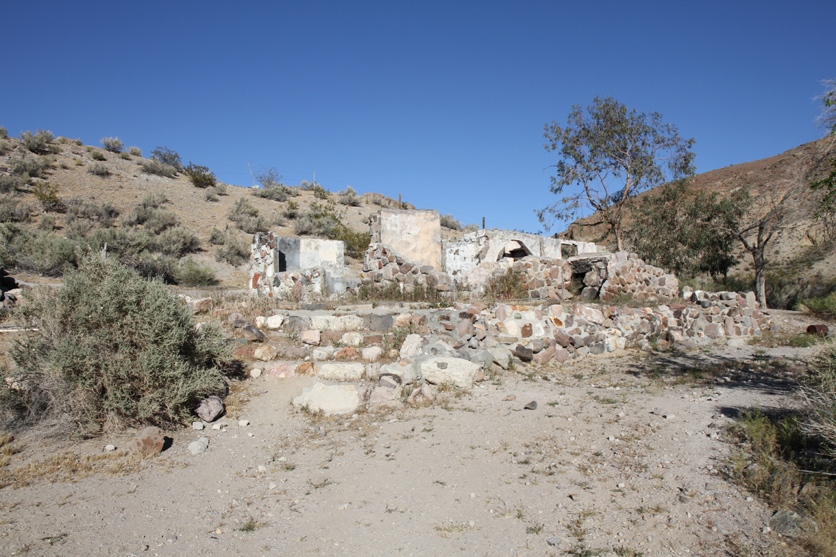
A view back towards the entrance, standing on Barker Ranch.
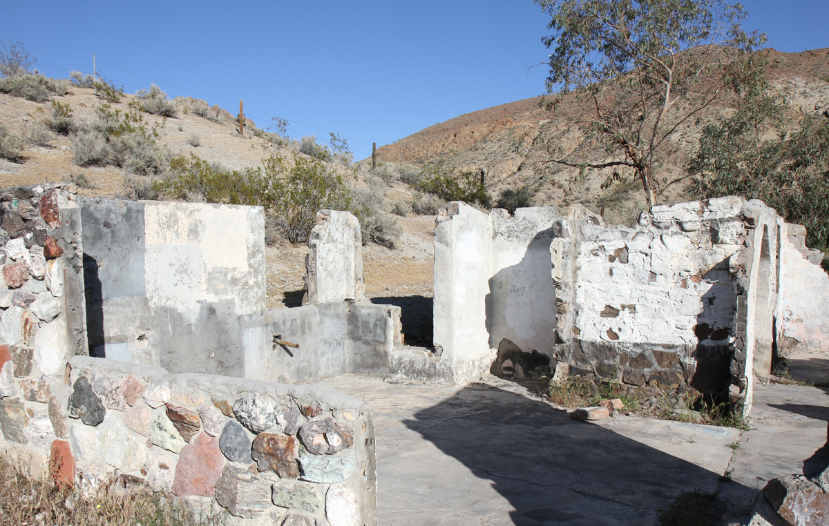
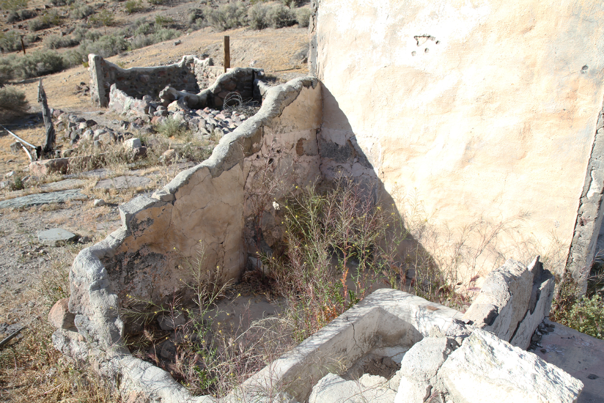
The remnants of Barker Ranch, as it is today. In 2009, a fire burnt down the majority of the building. However, the rock walls still partially remain, including the exact spot where Charles Manson was captured. The fire was reportedly accidental, when travelers passing through knocked over a grill. However, like so many things related to the Manson Family, this too has been called into question by some who believe it was intentional. In spite of the fire, it’s still fairly easy to identify each room in the remains of the ranch.
LOCATION: Just off of Goler Wash Rd., Death Valley National Park, Panamint, CA 93592 (easiest access is via Ballarat, CA, GPS coordinates: 35°51′34.57″N 117°5′18.76″W)
A closer look at the ranch, which was an extremely small building.
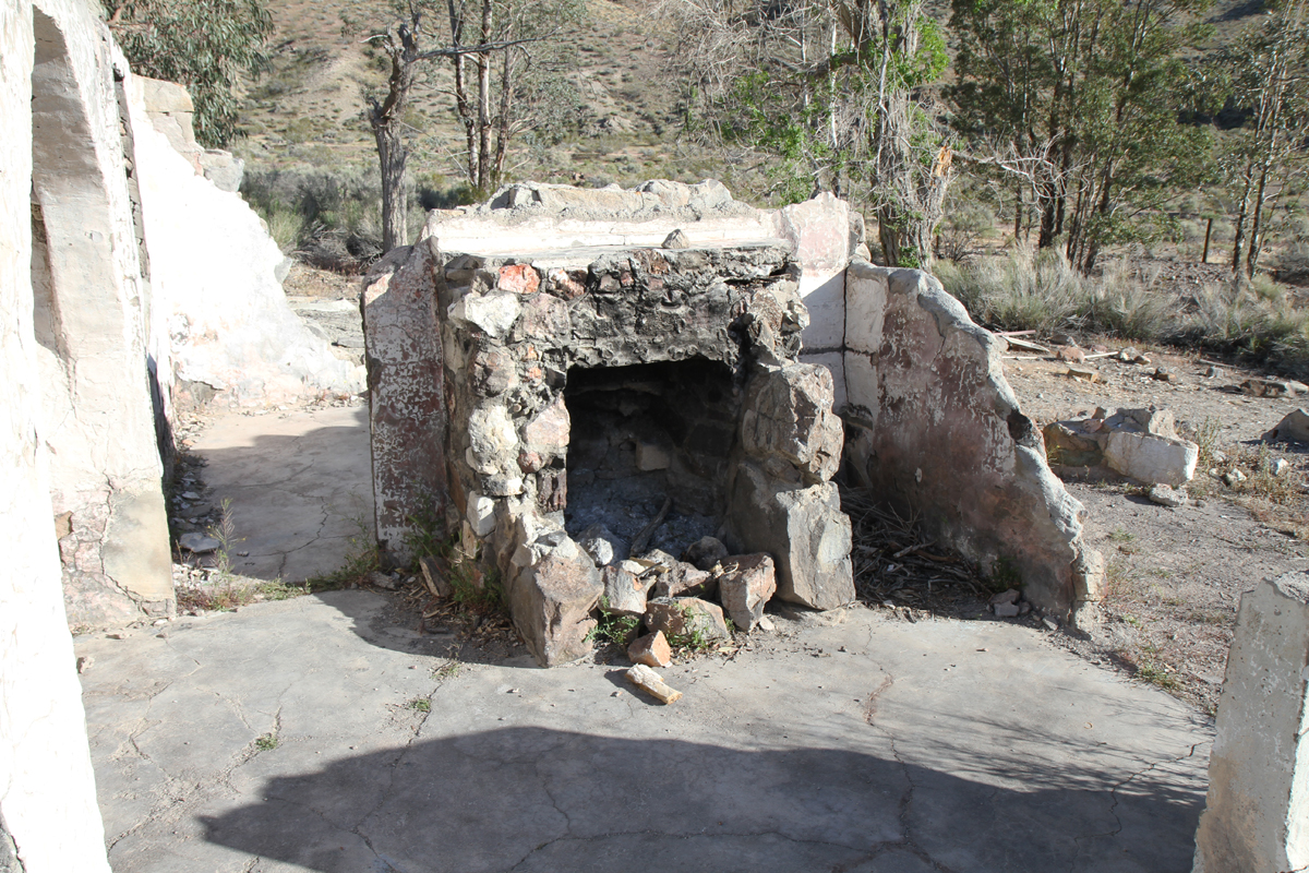
The fireplace, with a bedroom located behind it.
A seating area for eating.
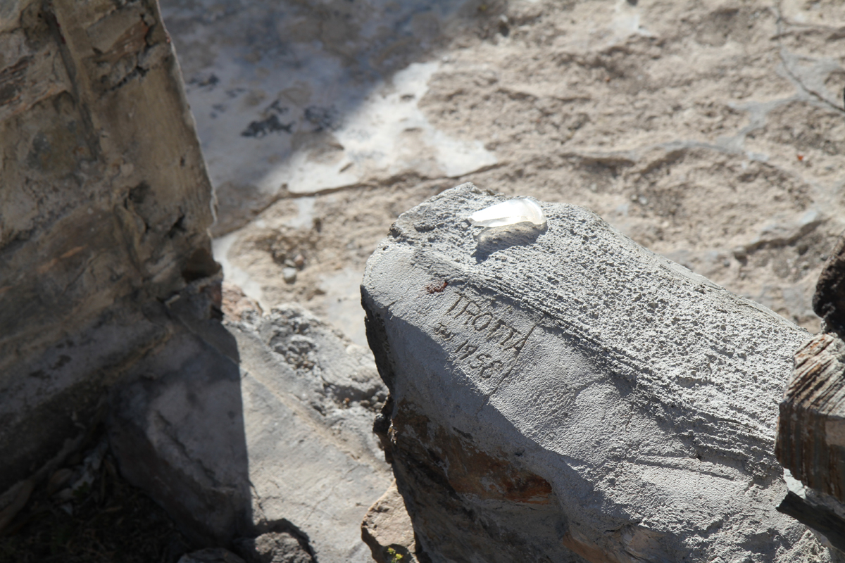
A spot where someone carved their name, circa 1958.
The bathroom, where Charles Manson was captured. The discoloration to the right is where the bathroom sink was located. Manson spent his last moments as a free man hidden in a cabinet beneath it, in a space so small the arresting officer claimed he would’ve never even thought to look inside of it, if not for a piece of Manson’s hair sticking out. Before he could open the cabinet door up, Manson opened it himself and crawled out and surrendered. The arresting officer was not aware at the time of the magnitude of his capture. Most of the Family was arrested on two separate raids of the ranch, on suspicion of vandalism to some nearby government-owned construction vehicles. Charles Manson eluded capture on the first raid, but was captured on the second raid. It was only during their holding in Inyo County that the Family’s connection to the Los Angeles murders was initially pieced together.
Another angle of the spot where Charles Manson was captured, showing how truly tiny the space was. Surprisingly, the ranch fire did not destroy this part of the building and it’s still clearly identifiable today.
One of the outbuildings on Barker Ranch. Manson Family members Paul Watkins and Brooks Poston stayed in this building. It was Watkins and Poston who told prosecutor Vincent Bugliosi of the “Helter Skelter” motive. According to Watkins and Poston, the murders were intended to start a race war between the blacks and whites. The Manson Family would hide out underground in the desert until the blacks won the war, then they would return to rule over the blacks, who they believed would be incapable of running a society themselves. Bugliosi used “Helter Skelter” as the primary motive in his case against Charles Manson, Charles “Tex” Watson, Susan Atkins, Patricia Krenwinkel and Leslie Van Houten and the theory became widely popularized as the motive for the murders. However, this motive has been disputed over the years. Many claim the murders were done as a copycat act, in an effort to make Bobby Beausoleil, who was a friend of the Family, appear innocent on the charges of killing Gary Hinman. Others still claim it was done as to instill fear into society, as an act of retribution for all the times those in power had rejected or imposed punishments upon the Manson Family. There are many different motives debated and the truth will likely never be conclusively agreed upon.
A view from behind the ranch. The most famous photos of the ranch from 1969 are from this angle, with the Manson Family bus parked to the center right of the frame. The bus was eventually dismantled and destroyed.
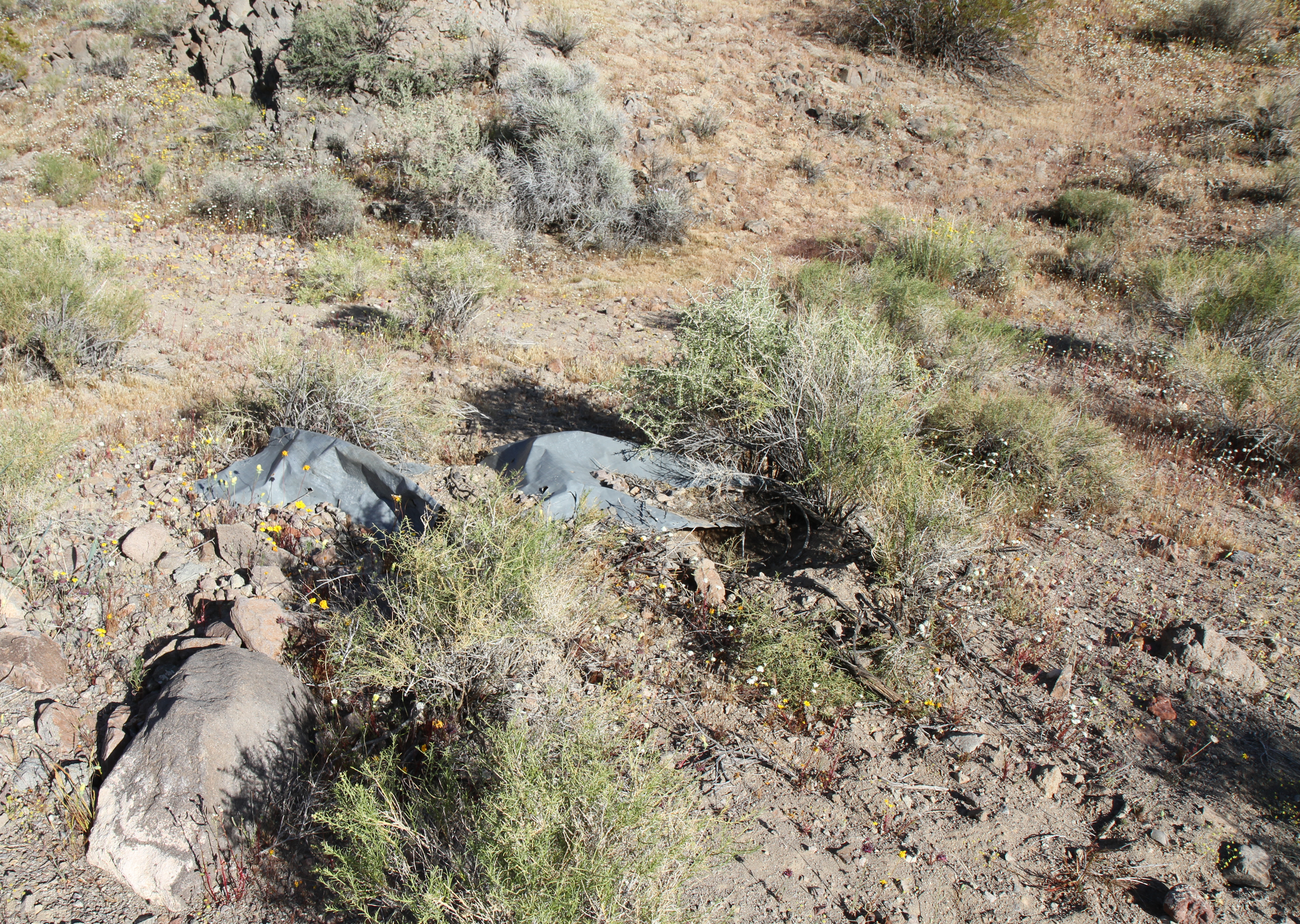
A swimming pool at the ranch, where members of the Family swam.
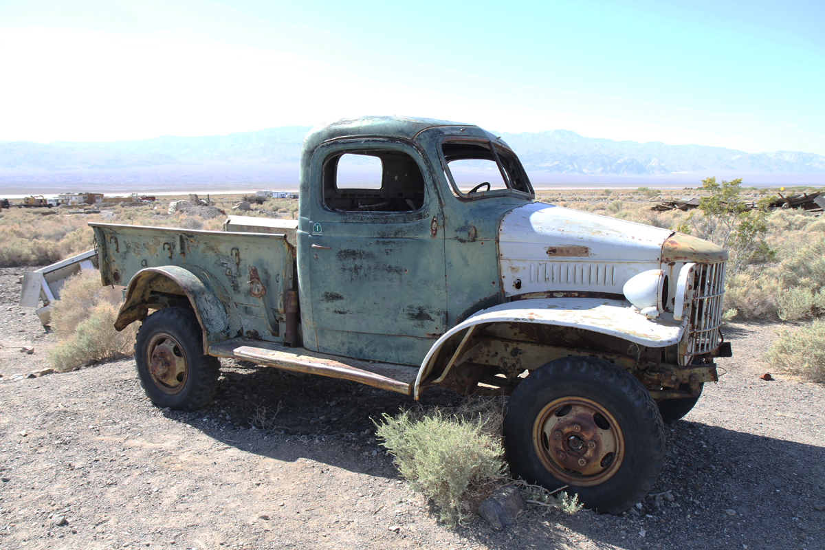
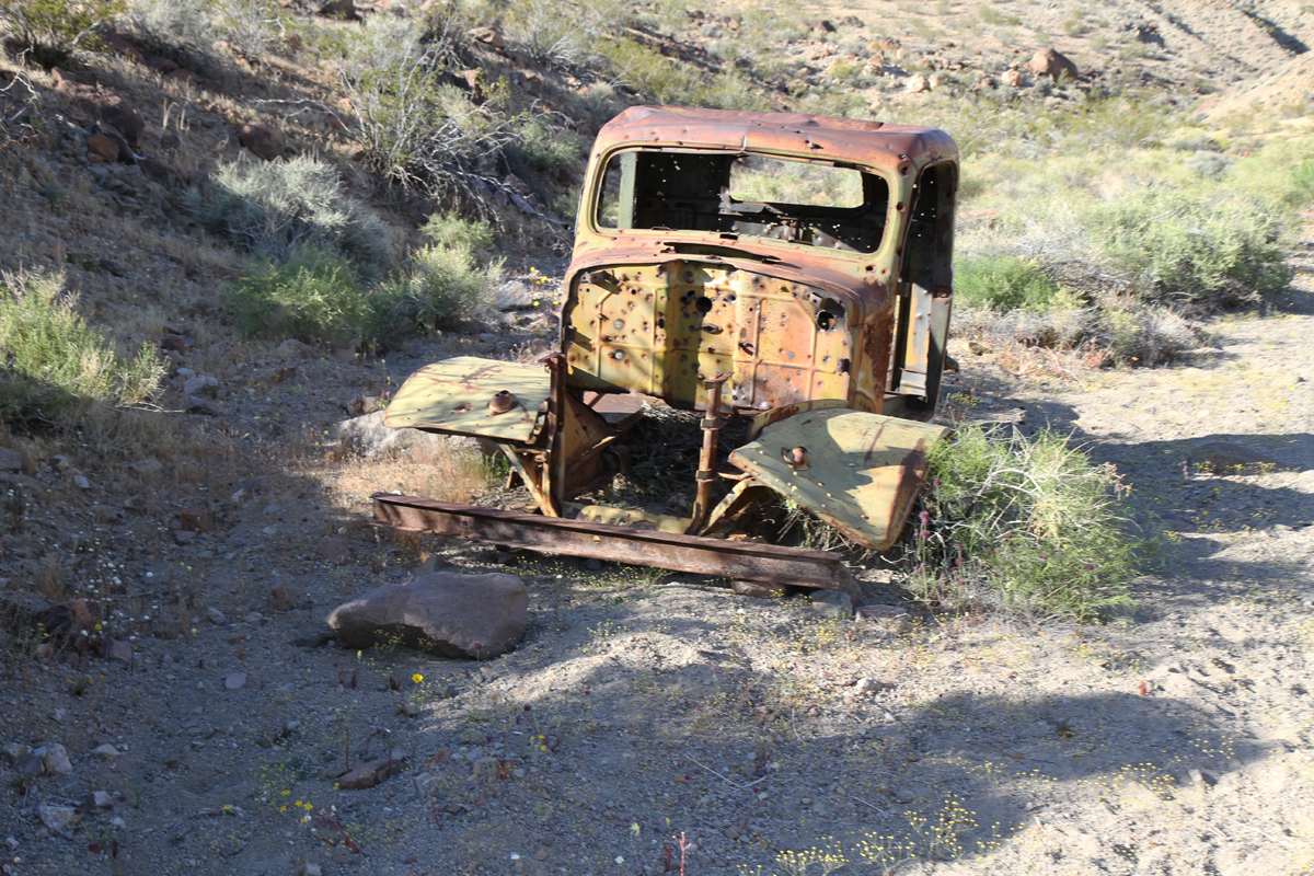
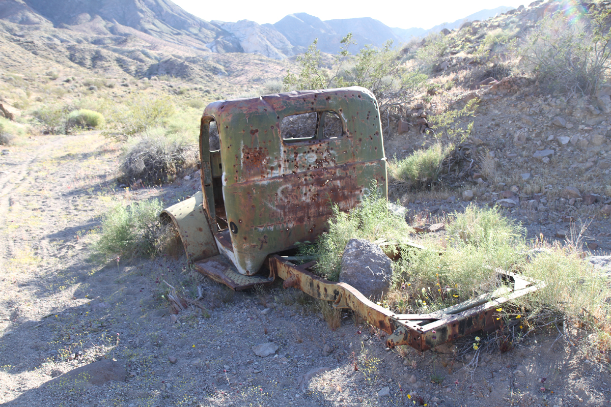
Many claim this is one of “Tex” Watson’s trucks, which is located behind the ranch. However, others dispute this as well. If you’re not familiar with the ranch, be careful in venturing back too far behind it, as it’s very easy to lose your bearings.
It’s difficult to make out through the rust and bullet holes, but the words “Helter Skelter” are written on the back of the truck.
Behind the ranch is also where some of the women were captured and arrested. The women were hiding in a hole in the ground, which was covered with some loose debris. This photo is of that approximate area, but perhaps not exact.
Another view behind Barker Ranch. From here you can get a better idea of just how small the building was.
A look at the nearby Myers Ranch, as seen from Barker Ranch. Members of the Manson Family also stayed at Myers Ranch. Today, it actually remains a private, occupied residence, unavailable for public visitation.
Footage of some of the members of the Manson Family at Barker Ranch can be seen in the Robert Hendrickson documentary “Manson,” which was nominated for an Academy Award, as well as his sister documentary, “Inside the Manson Gang,” which is mostly comprised of unused footage from the first film.
Barker Ranch is one of the most desolate places in the United States and it’s easy to see how one might have felt they could escape the eyes of the law in such a remote place. Everything there is sun-baked, rusted or worn down. It’s a unique experience to visit, but clearly one that is not for everyone. We of course do not endorse any of the crimes committed by those that took shelter here. Our aim is to simply show a unique place in American history, as it appears today.